- LIFESTYLE
- FASHION
- FOOD
- ENTERTAINMENT
- EVENTS
- CULTURE
- VIDEOS
- WEB STORIES
- GALLERIES
- GADGETS
- CAR & BIKE
- SOCIETY
- TRAVEL
- NORTH EAST
- INDULGE CONNECT

Braving the monsoon drizzle, a group of visitors arrive at Ojas Art gallery, drawn by the exhibition Cartographical Tales: India through Maps. Featuring 100 rarely seen historical maps from the 17th century to 1946, the exhibit traces the changing face of the Indian subcontinent due to political, social, economic, and geographical influences. “India’s geography has been shaped over centuries, and these maps narrate stories that transcend beyond their intricate demarcations. Each of these rare maps helps people relate to an era or period through their geographical enunciations and the altering boundaries they represent. One tends to discover something new on the same map daily!” shares Anubhav Nath, curatorial director, Ojas Art.
But why only maps up to 1946 and not after? “Most Indians are familiar with the post-Independence map of India, but not many know about the pre-Independence maps. There’s a lot of interest in that as it’s the same subcontinent, but there’s a difference in the way they look and feel,” Nath explains during our walkthrough. As the air fills with a growing sense of curiosity, some visitors whip out their map-reading tools rulers and magnifying glasses — as we explore some of the striking displays.
A world of exploration
The exhibition features maps crafted by prominent cartographers such as Matthaus Seutter, James Rennell, Pieter Mortier, Pierre Lapie, Rigobert Bonne, and John Tallis. Printed in various parts of the world, including England, France, Italy, and the USA, these maps provide enlightening insights into the Indian subcontinent. From a map published in 1786 by James Rennell, Surveyor General of India, showing the course of the Ganges from Haridwar to the sea, to the face of Delhi before the 1857 siege, published in The Illustrated London News in 1838, and Johann Baptist Homann’s well-engraved map of southern India and Ceylon from 1733, each map tells a different story.
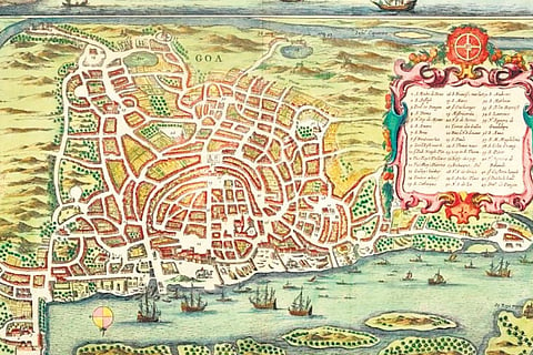
We stop by a visually-striking map of Goa—the main Portuguese trading post in India from 1510-1961—published in 1672. The illustrated map shows a bird’s-eye view of the town plan. It features drawings of a township, a harbour full of ships, a royal seal, a small compass rose, and two elephants at the harbour. On the left side is a cartouche identifying 43 buildings depicted on the map.
Next, a map published in 1687 captures our attention. It presents a rare view of the Red Fort along the banks of the Yamuna in Delhi, with the famous Diwan-e-Aam and Diwan-e-Khas clearly identifiable.
Another striking piece is a hand-coloured map of the northern Indian subcontinent from 1728 by Seutter, a stunning example of German cartography. It shows the vast expanse of the Mughal Empire stretching from the edges of Persia to the Gulf of Thailand. The map details key cities like Delhi, Agra, Kandahar, Kabul, Lahore, Goa, and Jaisalmer, as well as river systems, trade routes, and caravan trails.
Particularly captivating are the decorative allegorical cartouches in three corners of the map. The upper left side depicts child angels curious about a chest full of treasure, while birds and palm trees paint a tropical landscape, possibly representing the western gaze of exoticism on the east. The lower left-hand quadrant features Poseidon (the Greek god of the sea), Hermes (the Greek god of trade, wealth, and luck), an angel, and the goddess Pheme (associated with fame), admiring the wealth of Asia. The lower right quadrant shows trade ships resting in the Indian Ocean, signifying the Age of Discovery when Europeans explored new lands.
Moving on, several other maps provide vital information about forgotten aspects of history. For example, a 1788 map of the lower peninsula of India by Rennell provides extensive details of settlements, roads, hills, and rivers across southern states. It also reveals the local political powers in the region, such as the Country of Nizam Ally, Country possessed by Tippoo Sultan and Country of the Mahrattas.
The significance of cartography
Despite such an engaging display, one might wonder about the relevance of maps in modern times. Nath, who has been collecting maps for the last 15-20 years, explains, “Cartography is the art of graphically representing a geographical area. As an art form, it was at its zenith in the 17th-19th centuries when explorers discovered more places and could mark their exact geographical locations with the help of longitudes and latitudes. Cartography is also used for educational purposes as it helps in understanding changing geographical boundaries and the possible reasons behind them.”
The exhibition was also accompanied by an insightful session by Manosi Lahiri, author of Mapping India. The founder of ML Infomap, a company that promotes mapping and spatial solutions, shed light on why we need to engage with old maps in contemporary times. “It’s natural to question the importance of old maps in the present times of widespread use of digital and precise maps.
Old maps on paper, especially those made before the advent of steamships, railways, and photography, are prized by collectors as historical documents on the state of knowledge about places known to the west at that time, and also for being crafted beautifully with ornamental borders and cartouches,” she shared, adding,
“The historical maps of India were made by Europeans who arrived in sailing ships from the 16th century onwards. While these maps record shifting western geopolitical interests in the subcontinent in the following centuries, they also trace evolving survey and mapping practices, which are interesting and important aspects of old paper maps.”
Cartographical Tales: India through Maps will be on display till September 22 at Ojas Art gallery, Mehrauli.